

Does anyone know?Originally Posted by jerzybears


Does anyone know?
perrito
"If a man speaks in the woods, and there is no woman there to hear, is he still wrong?"


Looks like pavilion is visible from parking lot. Hang area is 1/2 mi. from parking lot.
http://www.dnr.maryland.gov/publicla...thlandmap.html
If you go to google maps you can see the parking on Arnoldstown road.
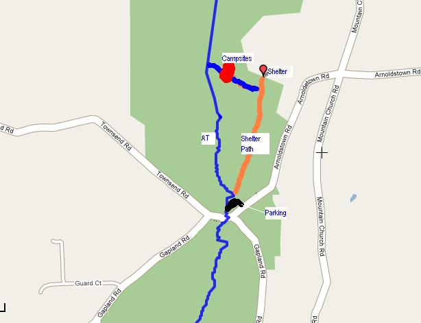
Found a map from Knotty (post #9):
http://www.hammockforums.net/forum/s...ead.php?t=7849
It sounds like the trail will be marked. Virtually idiot-proof!
Last edited by SilvrSurfr; 10-11-2011 at 13:52.
Less than 1/2 mile is my guess.

Post #92
That is an excellent map.
The "Shelter Path" looks like an old
4X4 road with a few blow-downs across
it.

On my way!
Support: HammockGear - Zpacks - Jacks R Better - DreamHammock - Dutchware - AHE - Black Rock - Grand Trunk
Might be a little late to ask this question, but if the pre-hikers aren't at the Garvey shelter on Thursday night, then where are the cliffs on the AT?
Hopefully someone will answer before Perrito and I hit the road at 8:30 am tomorrow. I'm thinking they mean Weaverton Cliffs
Last edited by SilvrSurfr; 10-12-2011 at 20:39.
I've got the waypoints plugged into my GPSr. We're good.
perrito
"If a man speaks in the woods, and there is no woman there to hear, is he still wrong?"
We're still at the shelter - rain rain go away!
Support: HammockGear - Zpacks - Jacks R Better - DreamHammock - Dutchware - AHE - Black Rock - Grand Trunk

SilvrSurfr- the Cliffs are south of the Garvey shelter..maybe 1.5-2 miles on a blue blazed trail.

Me so jealous. Pic looks great. Man I cant wait to get out and hang. Enjoy the hike every one and if their are any last minute items any of you need you can PM me and I'd be more then glad to bring um.
Sometimes I like to hike and think, And sometimes I just like to hike.
Hiking is'ent about waiting for the storm to pass its about learning to hike in the rain.
 Posting Permissions
")

 Reply With Quote

Bookmarks