


My oldest son (a.k.a. quantumcat) and I had a week's adventure in Northern Michigan and Wisconsin this last week. We started off hiking the Lakeshore Trail, through the Pictured Rocks National Lakeshore. This area is managed by the National Park Service.
We left home Sunday afternoon, and drove up to Cedar River, MI to camp one night at the JW Wells State Park. We pulled in around 10:30 p.m., went to the site I'd gotten a reservation for, and heard Lake Michigan nearby. Very nearby. There were excellent trees on the site for hanging, and so my son put up a Warbonnet and I put up my DMB. There was a brisk wind up, and so we broke out the Neat Sheets converted to underquilts, for a wind break. The night was clear and we were tired, so left the tarps packed up.
Here's the site in the morning. Lake Michigan was right past those bushes.
We made our way up to Munising, paid for our shuttle pick-up, picked up some lunch, and got our backcountry permit. You negotiate an itinerary with the Park Service that lists the nights you'll be camping at particular campsites, and pay on a per-night-per-person basis. They give you a pass to prove you have permission to camp. Once in the trip a ranger came up to us and asked to see the pass, so they do check.
We drove up to Munising Falls, the trailhead, and were off at about 1 p.m. Our destination was the Potato Patch campsite, 9 miles away.
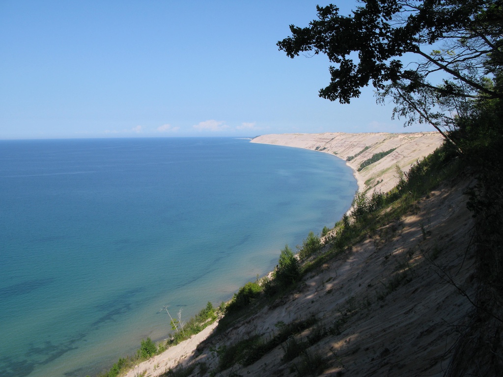
The Lakeshore Trail through the PRNL is a tourist trail. Clear and wide almost everywhere, usually flat. Most of the time it is near the ridge of 200 foot high cliffs above Lake Superior. About half a dozen times over the course of the 43 miles the trail descends quickly to lake level, where creeks or rivers come through, and where there are beaches. It then ascends just as quickly. Those parts are rugged, but there are few of them.
Here is a typical view of the trail.
We pulled into Potato Patch around 5:30 p.m. Our campsite was well suited for hanging. The park rules say that tents (and hammocks) need to be within 15 feet of a campsite marker, and here we had no trouble putting up and meeting that rule. Our site was just about half a mile past Miner's Beach, and so we walked back and spent the rest of the evening on the beach. (We did have one of those rugged ascent/descent bits between us and the beach though).
Day Two brought us some spectacular views of the lake and cliffs.
Clearly something was missing though...hmm...a hammock!!
By lunchtime we'd covered half of the day's allocated length---15 miles---and took a leisurely lunch at Cove Beach. Then strolled into our next campsite---Pine Bluffs---around 5:30 again. This one had trees but mostly more than 15 feet from the camp site marker. We hung with one hammock following the rule, and the other as close as we could get it. Spirit of the law rather than the letter of the law. It was to be on the warmer side that p.m., with little chance of rain, so we opened up our tarps (both JRB 11'x10') up pretty wide. Might have made the neighbors a little uncomfortable though when we changed.
Pine Bluff has beach access, so again I spent time down at the water, amusing myself. I did spend almost 10 hours in my hammock that night.
Day Three was another 15 mile one. A highlight was a leisurely lunch and hammock nap at 12 Mile Beach. One of the drive-in campers had pitched a Byer's hammock a bit further down the beach.
This is a very popular section of PRNL, we saw many trail hikers (mostly couples in their 20's), day hikers, fathers with young sons wandering around lost. There are drive-in campsites near the trail.
About three miles from our last campsite---Massey Homestead---is a light house. And signs saying that the last water to be had between here and the trailhead at Au Sable Visitor center (about 7.5 miles distant) was here. So we loaded up the Platypus bottles and soldiered on. A pint is a pound the world around, so filling up with an extra 4 liters to last the next 20 hours suddenly loaded me up with over 15 pounds I hadn't had before. Ugh. Plus we got to climb from lakeshore level to the top-of-dune level.
We were all business pulling into Massey Homestead campsite. We were the only visitors. It sits on the backside of the Grand Sable dune. There are lots of trees, an excellent hanging site. But sand everywhere, that gets into everything. We watched the sun drop then headed to bed.
We had only 4.5 miles to go in the morning to catch our shuttle at 11:30, so we had a leisurely a.m. This last stretch we hiked had spots where I got to wondering how often anyone ever hiked it. The eastern end of the trail, from the light house on to the Grand Sable visitor center, is clearly off the radar of the majority of the visitors.
It was an excellent hike. I can't remember any non-mountain trail I've been on with the density of great views. The frequent access to the lake was also a great feature.
We spent the rest of the day driving over to the Brule River in NE Wisconsin to meet with FishinFinn and continue the adventure. He's going to tell that story though.
<teaser>
did we ever find a site to hang on Friday night!!!
</teaser>
These pictures, and some more, are up at my picasa site.
Grizz


 Reply With Quote


 Thanks for sharing.


Bookmarks