


Good morning!
I had meant to post this earlier but I had completely forgotten until an hour ago.
For those of you who do not know, I can get lost so easily that it is embarrassing.
For those of you who are like me, I thought that this would help. Pictures included for the later and most confusing stages.
1. Once you arrive at the parking lot, look for the building. The building has restrooms, a big porch area, and a store. Walk towards the building.
2. While standing approximately 10 yards in front of the building, turn so that the building is on your right. Ahead, you should see a paved area located between dumpsters on the left and the building on your right. At the end of paved area is a fence, the path to the site is on the other side of the fence.
3. Once you pass the fence, hike up the dirt road area a short bit and the trail will be on the right. For a long way, the trail is easy to find and not confusing. If I remember correctly, as long as the trail is ascending, you have no real choices. Just follow the trail and climb.
4. When the trail starts to flatten (in comparison), is when the confusion can start. One of the first and, in my opinion, worst of the hidden turns occurs. The tree cover is also not as thick in this area as well. It looks like this
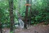
5. At this point you will soon be taking a left. Look for the Cat Gap sign on your left, it is not visible looking straight ahead, only if you are looking to the left. Here is a picture with the sign and the bridge. Note that the cable is your hand rail and you need to go very carefully across this bridge.
6. After you cross the bridge, you will be taking a right. Here is a picture of Lump showing the way. Note the trail blaze that he is pointing towards. Also the end of the cable of the bridge you just crossed.
This is the same picture but without a helpful Lump showing you the blaze. Lump and I thought it would be best to show the area as it would look. The picture still shows the blaze and the cable.
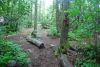
7. At some point, you will pass cross a bridge that is easily traversed. At this point, you are close to the hang site Note: this bridge has a nice log rail. Here is a picture:
8. The path will open eventually open up into an open wooded glade with the trees spaced at almost perfect hanging intervals. The glade is on the right.
The perspective of this picture is off for the approach. I was sitting in camp when I took this picture and I am looking out towards the trail. However, the picture does give a good impression of what the glade looks like.
Those of you that are veterans of this hang, please double check my directions. I do not exaggerate when I say I have directional issues. However, I navigate by sight and landmark so this should be fairly accurate since that is how I explained the steps.
I was not certain of the bridge order, cable bridge or log bridge first, but Lump says that the cable bridge is first.
I hope this helps.
Sincerely,
Sluggie


 Reply With Quote


Bookmarks