


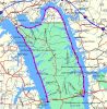
OK, I hope I'm understanding correctly where we will be paddling because my buddy NoFeather & I have been working on maps & GPS waypoints. Here's a pic of the map with the black dots representing one mile waypoints totaling 47 miles in all. Granted the route is set not too far from shore and if we paddle into coves, and I expect we will, of course the miles will increase.
Also if anyone would like the Garmin waypoints PM me your email and I can send you the file. You'll need to have a KY topo map downloaded for your MapSource or BaseCamp software to view it because most of this route is actually in Kentucky.

 Reply With Quote


Bookmarks