Page 1 of 2 12 LastLast
Results 1 to 10 of 15
  1. #1
    Senior Member Damifino's Avatar
    Join Date
    Jul 2010
    Location
    St Paul, MN
    Hammock
    BlackBird
    Tarp
    MacCat Delux
    Insulation
    HG 3/4 - UGQ TQ
    Suspension
    Whoopie
    Posts
    102
    Images
    25

    Foothills Trail - Table Rock to Bad Creek (Pics)

    (Photos taken with Garmin GSMAP-62STC GPS Unit)

    Headed out of Table Rock SP on Sunday, Sept 15, 2013:


    Mill Creek Falls on the Pinnacle Mtn ascent:


    View of Table Rock from Pinnacle Mtn Bald:


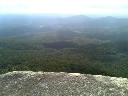
    View to the West from Pinnacle Mtn Bald:


    Old Cantrell Homesite:


    Sassafras Summit:


    Sassafras Summit:


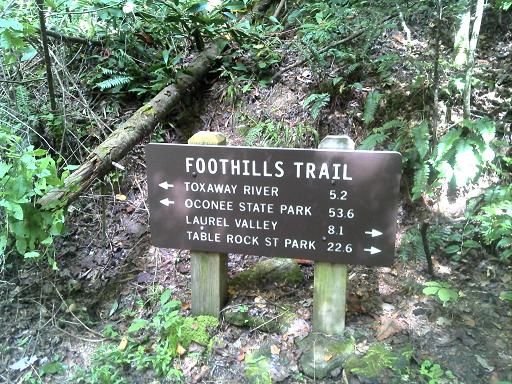
    Eastatoe Trail Access:


    Per my GPS, I made 18.3 Miles on day one. Camped at a site called "Intermittent Creek" between Eastatoe and Laurel Fork Creek. There was good water at the creek. A very nice campsite. Sorry no pictures of my setup, it was almost dark by the time I was set up each night. It was a mistake for me to log so many miles.

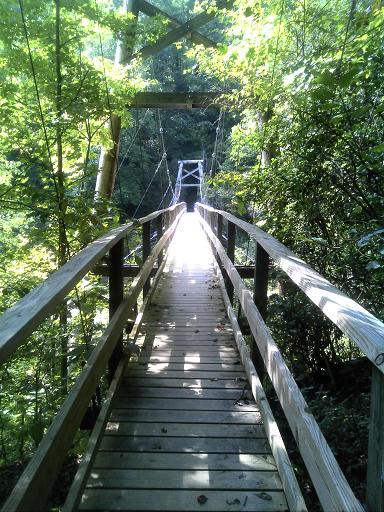
    One of about 15 bridges over Laurel Fork Creek:


    Virgina Hawkins Falls (sorry about pic quality - sweating all over the lens)


    Artful Bridge made with Mountain Laurel Wood:


    Another bridge over Laurel Fork Creek:


    Getting this pic is not worth the risk. Laurel Fork Falls is an 80' drop:


    From the Trail:


    Jocassee Boat access trailhead:


    Hiked over Heartbreak Ridge down to Lake Jocasse. My knee went from an ache that I was aware of to an ache that concerned me.

    Lake Jocassee. There are several great campsites here:


    Toxaway River Bridge:


    Stairs at Toxaway:


    Canebrake Boat Access:


    I camped at Bear Gap. The camp was used a few months ago by some inconsiderate *******s who decided their tent, air-mattress and blanket was to much to lug back out. They left it. The remnants were strewn about the camp like a rural dump. Most of the trees were girdled (why would you do this?). It was difficult to find 2 healthy trees here to tie onto. Sorry No pics again. I logged 18.6 miles on the GPS.

    The famous Horspasture River Stairs. Honestly, they are no more or less than 50 other sets of stairs on this trail. My Right knee is a real problem on day three - I decide to bail once I reach Whitewater River if I can get a ride:


    The quiet beauty of Horsepasture River:


    Bear Camp Creek Falls:


    Thompson River:


    Bad Creek Access Trail. The end of the trail for me. I would have liked to complete it but my knee would have none of it. I was thankful to get a ride to my car @ Oconee from some day-hikers. 2:15PM - Total miles on the GPS @ the Bad Creek Access parking lot = 51.1 miles:


    I will post some gear notes in the reviews section perhaps later.
    Tom

  2. #2
    Senior Member
    Join Date
    Sep 2011
    Location
    Palm Beach County, FL
    Hammock
    12' Dutchware Gathered
    Tarp
    12' Dutch's Bonded
    Insulation
    W Logics UQ 40F
    Suspension
    Whoopies
    Posts
    351
    Tom,
    I'm going to attempt the Foothills Trail on Nov1st starting at Oconee State Park. Any suggestions for a food drop? I was thinking somewhere near Whitewater Falls. If I start by noon on Nov 1, I figure Whitewater on Monday.

  3. #3
    Senior Member Duffy's Avatar
    Join Date
    Feb 2008
    Location
    Millinocket, Maine
    Hammock
    Sheltowee 20
    Tarp
    Speer
    Insulation
    Burrow
    Posts
    580
    Images
    12
    Thanks for the pics! Sorry to hear about your knee. I know the feeling (too well!).
    Something hidden. Go and find it. Go, and look behind the Ranges. Something lost behind the Ranges. Lost and waiting for you . . . Go! - Rudyard Kipling

  4. #4
    Senior Member Rain Man's Avatar
    Join Date
    Nov 2007
    Location
    Nashville, TN
    Hammock
    Hammeck Netty
    Tarp
    HG dyneema/MacCat
    Insulation
    DIY UQ and UGQ TQ
    Suspension
    whoopie slings
    Posts
    2,907
    Images
    8
    Thanks for the report and pics! Brings back memories. I had to bail on my initial FT hike too, but due to heat.

    I can't count the number of times I've read the theme of "I hiked too many miles and my knees gave out and I had to quit." You've got lots of company. Here's hoping for a speedy recovery.

    Rain Man

    .
    "You can stand tall without standing on someone. You can be a victor without having victims." --Harriet Woods

    http://www.MeetUp.com/NashvilleBackpacker
    .

  5. #5
    all secure in sector 7 Shug's Avatar
    Join Date
    Oct 2007
    Location
    Minnesota
    Hammock
    I have many so....
    Tarp
    Blackcrow DIY Tarp
    Insulation
    FrankenquiltUQ/Pod
    Suspension
    Whoopie Slings
    Posts
    23,422
    Images
    62
    Whoooo Buddy....that place always makes me want to go and trek it. Man, I hate that you tore up on that knee. Hope you get it back in tip-top shape.
    Shug
    Whooooo Buddy)))) All Secure in Sector Seven

  6. #6
    STinGa's Avatar
    Join Date
    Oct 2010
    Location
    Georgia, ^ of Atlanta
    Hammock
    DIY standard gathered end (DL 1.1)
    Tarp
    Chinook 12x9
    Insulation
    Nada ... yet
    Suspension
    DIY whoopies
    Posts
    1,337
    Images
    10
    Nice report, thanks for sharing your pics. It looks like a great place to spend some time.

    STinGa
    Sarcasm is a dying art.

    Eagle Scout September '85 Troop 339 Smyrna, TN

  7. #7
    Senior Member Damifino's Avatar
    Join Date
    Jul 2010
    Location
    St Paul, MN
    Hammock
    BlackBird
    Tarp
    MacCat Delux
    Insulation
    HG 3/4 - UGQ TQ
    Suspension
    Whoopie
    Posts
    102
    Images
    25
    O-Boy, There is a great food drop location at the bottom of Whitewater. It is at the Bad Creek Access where I quit. If you drive down to the Bad Creek Access parking lot from the Whitewater Falls overlook, take the .7 mile connector trail down to the trail. There are two bridges across the creek where it intersects the Foothills Trail. Anywhere down there is good but there is quite a bit of day-hiker traffic so hang the bag off the trail a distance. I put a note on the cord to (hopefully) discourage anyone who happens to find the cache.

  8. #8
    swampfox's Avatar
    Join Date
    May 2008
    Location
    Simpsonville, SC
    Hammock
    Warbonnet Blackbird XLC
    Tarp
    Hammock Gear Quest
    Insulation
    Warbonnet Wookie
    Suspension
    Whoopie slings
    Posts
    1,161
    Images
    35
    That's an awesome trip report.
    I did a portion of that from Bad Creek to Laurel Valley 3 weeks ago,
    We took a lot of the same pictures!

    Sorry about the knee. Get it healed and get back out there. The next piece, from Bad Creek up the Whitewater River corridor to Whitewater Falls is one of my favorite hikes.

    good luck

    Swampfox
    He is your friend, your companion, your defender... he is your dog. You are his life, his leader, and master. He will be yours, faithful and true, to the last beat of his heart. You owe it to him to be worthy of that devotion.

  9. #9
    Member
    Join Date
    Jul 2013
    Location
    Northern wi
    Posts
    59
    Thank you for the nice pictures of the trail and laurel falls.Take care of the knee so you get back out there.

  10. #10
    New Member
    Join Date
    Aug 2013
    Location
    pleasant garden
    Posts
    1
    I enjoyed your post. I hiked this June 2012, and the "big middle" laurel valley to Whitewater falls once before in 2002. Both times were fantastic.

    Last year the first three days were near constant rain, heavy at times and I was totally soaked, just kept walking with minimal rest/photo breaks. Near heart break ridge I slipped on one of those treacherous trail steps fell backward head firs down the hill, with my feet pointing up hill, doing the disoriented turtle dance. Luckily I was unhurt. Any how, I am ready to go back it was so beautiful and the trail was maintained extrmely well. Here is a link to my trip if you would like to visit.
    http://www.flickr.com/photos/soleful...7630018807070/

  • + New Posts
  • Page 1 of 2 12 LastLast

    Similar Threads

    1. Foothills Trail from Oconee to Bad Creek
      By Theosus in forum Trip Reports
      Replies: 6
      Last Post: 04-03-2014, 14:30
    2. Foothills Trail May 17,18 Bad Creek to Bearcamp Creek
      By BigRed77 in forum Trip Reports
      Replies: 5
      Last Post: 05-21-2013, 11:08
    3. Table Rock State Park and the Foothills Trail
      By streamline in forum Trip Reports
      Replies: 25
      Last Post: 01-01-2013, 21:53
    4. Foothills Trail: Bad Creek to Oconee State Park
      By HannahsDaddy in forum Trip Reports
      Replies: 8
      Last Post: 02-29-2012, 18:04
    5. SC Foothills Trail Jocassee / Bad Creek Sta.
      By diesel in forum Hangouts, Campouts, and Trip Planning
      Replies: 36
      Last Post: 05-31-2010, 09:44

    Bookmarks

    Posting Permissions

    • You may not post new threads
    • You may not post replies
    • You may not post attachments
    • You may not edit your posts
    •