Page 1 of 3 123 LastLast
Results 1 to 10 of 25
  1. #1
    TallPaul's Avatar
    Join Date
    Aug 2012
    Location
    Charlotte, NC
    Hammock
    WBXLC, WBBB, LiteOwl
    Tarp
    Superfly, MambaJam
    Insulation
    HG Phoenix, WL Sum
    Suspension
    Webbing, Whoopies
    Posts
    4,076
    Images
    13

    SC/GA/NC/TN -> Southern Appalachian 500


    I’m trying out a long form trip report. We’ll see how it goes.

    PART 1: The Route

    https://caltopo.com/m/LFRG

    This post is meant to inspire those backpackers that dream about trails, mountains, waterfalls and rivers. And those of us that like to look at maps and consider all the possibilities.


    I found myself in such a position this past year when I was trying to figure out what trail or trails I wanted to do next. I had a few areas I hadn’t crossed off my list yet - the Foothills trail in SC; the Black Mountain Crest trail near Mt Mitchell; the AT from Winding Stair Gap to Nantahala or Fontana; the AT through GSMNP.


    Part of my research lead me back to some loops I had bookmarked but kinda forgot about. There was the old Blue Ridge Outdoors article on Matt Kirks 350 mile Southern Appalachian Loop Trail. And the lesser known High Country Loop Trail by Adam at WACPhotography, which I stumbled across watching a video by Neemor’s World on YouTube and subsequent video by Douglas Hurdle (well done BTW).


    Well you can guess what happened next. I started connecting the dots and realized there was route that would cross off a lot of areas I had on my To Do list.


    The Southern Appalachian 500 is the name I came up with while hiking part of the route this spring. I had posted another name on HF but it was a mouthful. And I liked how this one sounded a bit like a Nascar race which we’re known for in this parts. Anyway, it’s a 500+ mile route that connects 4 large trails (Foothills, Bartram, Appalachian Trail & the Mountains-to-Sea trail) and a few smaller ones - Chattooga River trail, Black Mountain Crest Trail, Grandfather Mountain trails.


    The SA500 route connects many beautiful areas across SC, NC and TN, including
    • Beloved Western Carolina areas: Shining Rock; Grandfather Mtn; GSMNP; Foothills Trail; Roan Highlands; Linville Gorge; Mt Mitchell / Black Mountain Crest Trail
    • Tallest mountains - Mt Michell (NC highest); Clingmans Dome (TN highest); Rabun Bald (GA 2nd highest) and Sassafras Mountain (SC highest)
    • 6000' peaks - the route goes on or near 25 of the 6000' mountains.
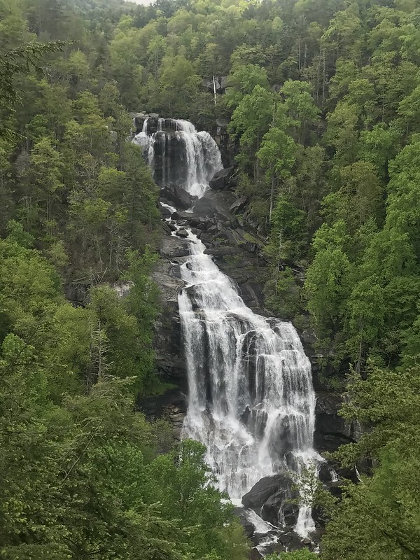
    • Waterfalls & rivers: excellent river hiking and waterfalls near the Chattooga River trail and Wilson & Steels Creek.

    I was pretty excited after coming up with a plan. Early spring had me finalizing gear lists, food options and resupplies, and trying to get in some sort of backpacking shape.

    Next up.... (after I write it - ha)....

    PART 2: The Foothills and Bartram trails
    Last edited by TallPaul; 10-17-2019 at 14:18.

  2. #2
    Senior Member Cabmanhang's Avatar
    Join Date
    Jan 2017
    Location
    GGE
    Hammock
    DIY 12ft HyperD 1.6SL
    Tarp
    The Stingray DIY
    Insulation
    Incubator/Gemini
    Suspension
    UCRWhoopieCinch
    Posts
    821
    This may be one of the most epic routes ever planned. Definitely keeping up with this!

  3. #3
    Senior Member u.willie's Avatar
    Join Date
    Mar 2013
    Location
    VaBeach
    Hammock
    Mine-ziz.... Nachos
    Tarp
    Yuge
    Insulation
    safishent
    Suspension
    MSH, 1.4gpf straps
    Posts
    204
    Oh Holy Crap WOW! I am inclined to agree with Cabmanhang. At least in that area of our country I think - Totally EPIC route indeed!

    You have my undivided attention with this, and thank you for posting! I am VERY much looking forward to more info in the future.

    I have hiked some of that trail(s)/route already: the AT, and the Foothills Trail. I plan to hike the Bartram Trail this year (hopefully) too.

    willin'

  4. #4
    Member mad_matze's Avatar
    Join Date
    May 2019
    Location
    Hamburg, Germany
    Hammock
    SLD Trail Lair
    Tarp
    SLD .9oz Asym Tarp
    Insulation
    LL Operator Series
    Suspension
    Whoopies
    Posts
    61
    Wow, good luck in the mountains! I hope the weather gods will be in a good mood for you!

  5. #5
    Senior Member Grunt's Avatar
    Join Date
    Mar 2019
    Location
    IN
    Hammock
    Amok Draumr XL
    Posts
    224
    Holy schnikeys, that sounds like a challenging but amazing route! I like your ambition, sir. Looking forward to seeing how it goes for you.
    Oooh, shiney! What does THIS button do?

  6. #6
    TallPaul's Avatar
    Join Date
    Aug 2012
    Location
    Charlotte, NC
    Hammock
    WBXLC, WBBB, LiteOwl
    Tarp
    Superfly, MambaJam
    Insulation
    HG Phoenix, WL Sum
    Suspension
    Webbing, Whoopies
    Posts
    4,076
    Images
    13
    Quote Originally Posted by Cabmanhang View Post
    This may be one of the most epic routes ever planned. Definitely keeping up with this!
    Not sure about the most epic routes ever but its fun to connect trails in a way that few have before.

    Quote Originally Posted by u.willie View Post
    Oh Holy Crap WOW! I am inclined to agree with Cabmanhang. At least in that area of our country I think - Totally EPIC route indeed!

    You have my undivided attention with this, and thank you for posting! I am VERY much looking forward to more info in the future.

    I have hiked some of that trail(s)/route already: the AT, and the Foothills Trail. I plan to hike the Bartram Trail this year (hopefully) too.

    willin'
    Hopefully some of the info will help. I can definitely recommend the Bartram though I've only done it from SC/GA border to Franklin. I've heard the climb out of Franklin is pretty tough with lots of elevation gain and little water. One of those you should get a shirt for if you complete it.

    Quote Originally Posted by mad_matze View Post
    Wow, good luck in the mountains! I hope the weather gods will be in a good mood for you!
    I've already done half the route & the weather was great. 18 day and only one with rain. Can't get much better.

    Quote Originally Posted by Grunt View Post
    Holy schnikeys, that sounds like a challenging but amazing route! I like your ambition, sir. Looking forward to seeing how it goes for you.
    Thanks Grunt.. part II coming shortly.

  7. #7
    TallPaul's Avatar
    Join Date
    Aug 2012
    Location
    Charlotte, NC
    Hammock
    WBXLC, WBBB, LiteOwl
    Tarp
    Superfly, MambaJam
    Insulation
    HG Phoenix, WL Sum
    Suspension
    Webbing, Whoopies
    Posts
    4,076
    Images
    13
    Part 2: Foothills trail. Table Rock State Park to Whitewater Falls. 4 days, 50 miles

    Notes:
    • This section occurred April 28 - May 1
    • Hiker registration: required - see the Foothills website for more details
    • Water sources: Generally plentiful (April/May 2019) though I did forget to fill up before going up a ridgeline like a dummy
    • Campsites: See SwampFox's posts here on the forums. Plenty of options especially for those hammocking
    • Difficulty: Tough if you are out of trail shape due to steep ups but go easier the further west I went


    Day 1 Table Rock to Camp Sassafras 7.8 miles

    Most of day one was consumed with driving to the trailhead in upstate South Carolina; taking care of a food drop; and eating a lunch buffet at nearby Aunt Sue's. Nothing like hiking after you basically eat a Thanksgiving quantity meal! The food drop was due to the 97 miles between Table Rock and the next town of Clayton, GA - the longest stretch between towns on this 500 mile route.

    After I was dropped off at Table Rock State Park, I registered for my hike at the ranger station. Registration was free since I wasn't parking a car at the State Park.

    There were lots of folks on the trail but it thinned out quickly. Hiking this trail east to west means you start with a fair amount of elevation gain, eventually climbing to Sassafras Mtn, the highest point in South Carolina. The good news is it was a steady climb. Lacey (my beagle) and I climbed up to Bald Knob. Just wow. I was impressed with the fantastic views over upstate SC. The spring flowers were also out in abundance, which meant a fair amount of lollygagging taking photos. We stopped a few miles short of Sassafras Mtn and spent the night along a small creek. Very tranquil.


    Day 2 Camp Sassafras to Virginia Hawkins falls campsite 11.8 miles

    We finished the climb up to Sassafras Mtn (tallest in SC) in the morning. I was surprised to see the newly built tower at the top as videos I had watched before didn’t show it. I found out the overlook had just opened a week before. Later the trail followed Laurel Fork Creek and I was amazed at all the well constructed bridges as the trail bounced back and forth over the river. The trail maintenance folks do great work on the FHT. The last bridge was damaged by a tree falling on it so we crossed the old fashioned way - fording the creek.

    We arrived at Virginia Hawkins Falls and the nearby campsite. Both were unexpected and such treats. We had a relaxing night with camp to ourselves. Dinner consisted of Skurka mashed potatoes and dog food by a camp fire. Lacey was a tired dog that night but perked up to look out of the hammock at all the fireflies before closing her eyes.


    Day 3 Virginia Hawkins Camp to Camp Bear Gap 14.5 miles

    I slept in till 8:30 and woke up to another beautiful sunny day. Not long after getting on the trail I ran into two other backpackers - John followed later by Artie. It was lucky for John I ran into him. He thought he was hiking eastbound but had gotten turned around due to a trail re-route sign.

    I took a side trail to the top of Laurel Creek Falls, then later saw the falls from the FHT as it dumps into Lake Jocassee. I'm guessing the best way to see this waterfall is from a boat on the lake. I took a side trail down to the lake and took a dip. It felt good to wash and cool off. One nice thing about solo hiking is you can do whatever you want.

    Dummy me forget to refill the water bottles before climbing a ridgeline and I paid for it as the trail climbed and I ran out of water. Lacey drank some brown puddle water. I wasn’t that desperate. I ran into Artie again and hiked with him. He is legally blind - he still has some vision but not a lot. I called him Wine Sherpa after he magically pulled some out of his pack and shared a bottle with me - it tasted good after a long day. We camped at Bear Creek Gap - the first time camping with somebody else this trip.

    I'll mention there was no phone reception as we had entered a more rugged part of the wilderness. I usually send my wife a message once a day to let her know I'm good but couldn't this day.


    Day 4 Camp Bear Gap to Eagle Scout Camp / Whitewater Falls 16 miles

    Toward the end of day 4, I finally got cell reception and received ~60 messages, which is a lot for me. The first one I saw caused me to call home and make a plan to get off the trail the next morning. But let’s rewind a bit.

    Artie, Lacey and I had a nice morning breaking down camp and getting on the trail. While I’m fine solo camping, it was nice to hike and hang out with Artie. Artie runs up & down a deserted road by his house and had his trail legs. I was breathing hard up the hills.

    We crossed a number of bridges again - the Foothills Trail is very well maintained and has signs throughout telling you distances. The trail is well blazed. There were a couple times I thought they could have added a blaze but overall easy to follow. I did miss a junction once & walked a 1/2 mile off trail

    We came across some fellow HammockForum members backpacking the other direction. The interesting part is I heard Sidney Hornblowers voice first & recognizing it from YouTube. Always fun to meet people in real life that you interact with online.

    We had a climb up to the overlook for Whitewater Falls and WOW WOW WOW. The wet/rainy spring meant water rushed over the falls. So beautiful to see. I didn’t expect anything so grand. Virginia Hawkins and Whitewater Falls are right up there with some of the best waterfalls I've seen.

    Once I got to the parking lot for Whitewater Falls I tried my phone again. 60 messages or so rolled in which is a ton for me. The first message I read from my wife said she was “evacuated from the building with their hands in the air” as SWAT looked on. I keep reading and found out my wife (who works at UNC-Charlotte) was on campus during a shooting on campus the prior evening. Thankfully she was safe. I made plans with her to come pick me up the next day so we could be together. Then I continued on to Eagle Scout Camp for another night hanging with the Wine Sherpa.

    Last edited by TallPaul; 10-21-2019 at 19:38.

  8. #8
    Senior Member mistone's Avatar
    Join Date
    Nov 2014
    Location
    Oak Hill nc
    Hammock
    DIY WINTER HAMMOCK
    Tarp
    Diy Winter Tarp
    Insulation
    Down
    Suspension
    Dutch gear
    Posts
    604
    Images
    16
    What a great route Paul Pretty amazingA lot of good places and scenic places to go to all in one region pretty much
    Its a good day to be out in the woods no matter the weather.Mist One..

  9. #9
    TallPaul's Avatar
    Join Date
    Aug 2012
    Location
    Charlotte, NC
    Hammock
    WBXLC, WBBB, LiteOwl
    Tarp
    Superfly, MambaJam
    Insulation
    HG Phoenix, WL Sum
    Suspension
    Webbing, Whoopies
    Posts
    4,076
    Images
    13
    Part 3: Foothills Trail,Chattooga River Trail & Bartram trail. Whitewater Falls to Franklin, NC 80 miles

    Notes:
    • This section occurred from May 14 - 19
    • Water sources: Plentiful with a couple exceptions:
    • DIcks Creek to Warwoman Dell[/INDENT]
    • Martin Creek to Flatop Mtn (or possibly beyond)


    Day 5 Whitewater Falls to Chattooga River campsite 17.7 miles

    Left home at 5am and stopped at the Waffle House near the Big Peach in Gaffney for breakfast. They were out of coffee. What?!!! Fortunately, the day only got better after that.

    I parked at the dirt parking area near Whitewater Falls and was on the trail by 8:30. The trail started with a short climb but then proceeded gently as the big FHT climbs are mostly behind me. I’ll remember this day as one I just cruised. The elevation profile... being rested... trail of pine needles - not rocks and roots... I seemed to flow down the trail.

    I stopped at King Creek Falls for lunch. Its .5 miles offtrail. It is another beautiful waterfall. I tried cold soaked ramen & a thai peanut sauce. It was ok. Not sure the cold soaking thing will stick. After lunch, the trail paralleled the Wild and Scenic Chattooga River. So peaceful. In fact, I stopped and took an after lunch nap in the hammock

    Further down the river, I took an unmarked side trail down to Big Bend Falls. It was a scramble - holding onto roots to keep from sliding. But WOW the payoff. I came out near the middle section of a fairly raging waterfall - it felt like you were in the waterfall.

    I hiked a bit more and ate dinner on a sandy beach. Very peaceful. Then a bit further to find a campsite and ended up having a great campsite along the river all to myself.

    This was my last full day on the Foothills trail. It has been a wonderful trail and I’d highly recommend it. I lucked out and had sunshine the entire time. And water was flowing. So YMMV but definitely something to put in your list. Next up is the Chattooga River trail and Bartram trail.


    Day 6 Chattooga River campsite to dry campsite past Dicks Creek 19.7 miles

    As I went to bed the prior night, I realized I forgot my iPhone charging cable in the truck. UGH. I shot a lot of pics and videos the day before so my phone was down to 14% remaining. Definitely not enough to last till Franklin, NC.

    I said goodbye to the Foothills trail this morning. In total I completed 65 of the 74 FHT miles and have nothing but fond memories of it. I’ll be back to finish off the last bit of the FHT (Licklog to Oconee SP).

    I then hiked a ~4 mile portion of the Chattooga River trail to connect up with the Bartram trail. The CRT had a number of great looking campsites that I noted for future trips. It wasn’t long before I found myself in Georgia starting the Bartram trail.

    The Bartram Trail is probably the least known and frequented of the trails I’ll be on. I continued hiking on the Georgia side of the Chattooga River then climbed up and down drainages. I stopped at Dicks Creek Falls - highly recommended. The creek goes over a beautiful waterfall then flows into the Chattooga, which happens to have its own set of cascades. Really a place you have to see.

    After that side trip, I loaded up 4 liters of water. I knew I would be dry camping (no creeks or other water sources at camp) so I sucked up the extra weight and continued uphill. I found a couple trees beside the trail to setup the hammock and called it a day.

    One surprise about the Bartram Trail was how well it is blazed - even better than the FHT if you can believe it. I’d rank the blazes (best to worst) - BT, FHT, AT, MST. Again thanks to the trail maintenance folks for the awesome job.


    Day 7 dry campsite past Dicks Creek to Martin Creek camp 7.5 miles

    Starting from the SC/GA terminus, the Bartram trail heads west along the Chattooga River toward the town of Clayton, GA. From there, the trail heads north to Franklin, NC. I had intended to resupply in Franklin (a hiker friendly town with the AT nearby) but since I lost my phone charger, I decided to hitchhike into Clayton.

    I hiked along the dry ridgeline until it dumped me out at Warwoman Dell and a road. I walked a mile (?) or so until the road straightened out and put my thumb out. A nice sheep farmer in a truck loaded down with hay bales picked me up and dropped me at the Walmart.

    I resupplied food, bought a charger, and downed a Subway sandwich and Coke before trying to get a ride back to the trail. No luck, so I walked along the road with the Georgia sun beating down on my neck. After a couple miles walking and a different road, I finally got a hitch in the back of a pickup truck. I held on tightly on the twisty roads.

    I headed north with the trail quickly gaining elevation and got to Martins Creek Falls and campsite. I called it a day as it was a nice campsite and there were limited camping options ahead - and all dry.

    It was a short mileage day - 7 plus a few bonus miles in Clayton. Have I mentioned the great weather? Another night looking up at the stars from the hammock as I didn’t need to deploy the tarp.


    Day 8 Martin Creek campsite to DIY camp just south of GA/NC border 15.3 miles

    I woke up at 6 am - news alert I’m not a morning person. I’m sure it is because I was well rested after going to bed at “hiker midnight”.

    So far the Bartram trail had been increasingly getting more challenging. The eastern portion seemed relatively flat following the river basin. Then rolling ups and downs as it went in and out of drainages followed by the long ridge walk before Warwoman Dell. Today starts the elevation climb to Rabun Bald, the second highest peak in Georgia. The northern part of the trail gets even more mountainous.

    A storm hit 90 minutes into the hike - lightening, thunder and rain. It looked like a short one so I setup the tarp. Then I thought I'd be more comfortable in the hammock. Then I thought heck I might as well nap if I'm laying down in the hammock. Ha.

    I saw my first snake today. The few hikers I’ve seen have been sharing they have seen them but I had not until today. It’s always a bit tricky when the trail is partially sunny then shaded. They are probably there & I just wasn't seeing them.

    I finished the big climb of the day and the payoff - the Rabun Bald lookout tower. WOW. The 2nd highest mountain in GA did not disappoint. The viewpoint has a one-story platform to enjoy 360 degree views of GA/NC/SC. I hung out watching the clouds & drying sweat soaked clothes. A rain shower had been moving thru the mountains north of me when suddenly - BOOM - thunder right above me. It didn’t take long for me to get off the highest point around.

    I made camp along the trail near a creek, just south of NC 106. It was a hammock camping special - just a couple of trees off trail and a creek not far away. Tenting would have sucked.


    Day 9 south of GA/NC border to Whiterock Mountain 13.3 miles

    Two big events this morning. One, I crossed over into North Carolina. I’ll be in NC for most of the remaining route, with some miles in TN.

    Second and more exciting... I wasn’t 5 minutes into my hike and I see a WILD BOAR. Took my brain some time to process what I was seeing. Dog? Bear? Then it dawned on me. Boar

    A feral hog / boar is one of the animals I’d rather not encounter as I’ve heard they can be aggressive. At least that's what came to mind as I tried to bring up boar related data in my brain. The boar had no cares and took its sweet time - walking, stopping, looking back, etc etc. I grabbed a club, threw a few things at it. It finally went off trail enough I could get by it.

    After that excitement, I crossed NC106 and climbed up Scaly Mountain and enjoyed the views. The wildflowers were out, so I stopped and took lots of pics. The trail then lost elevation to Tessentee creek then gained it all back climbing up to Jones Gap. That portion up Jones Gap was a surprise - it didn't look that bad on the map but it was a steep & constant uphill, often leaving me winded.

    I ended the day camped on top of Whiterock Mountain. There weren’t a lot of trees for hammocking but I found a couple. After setting up camp I went to a viewpoint and MORE great views out over the valley. I ended up coming back after super and watching the sun go down. Beautiful. I could see Standing Indian in the distance.


    Day 10 May 19 Southern Appalachian 500 / Bartram trail

    The day started off nice and cool under overcast skies. There was a chance of rain so it motivated me to pack while my gear was dry and get on the trail at a decent time.

    I ran across an abandoned yellow school bus on the trail. As I came up on the bus, I wondered how in the world it got there. The trail didn’t seem like an old roadbed or rail grade. I still haven’t figured it out. It did remind me of the story Into the Wild about Chris McCandless in Alaska.

    I had decided to get off trail in Franklin for the weekend to spend time with my family. I arranged a shuttle for the next portion of my hike - from Franklin to Oconoluftee Visitor Center. The only portion left was getting to Franklin to get picked up by my wife. The trail dumped me out on a road & I was able to hitch into town.

    All told, I had hiked 130 miles over the past 10 days on the Foothills trail, Chattooga River trail and the Bartram trail. Next up - I had originally planned to hike the Bartram up to Wayah Bald on the AT but heard from a number of folks that it was a tough and dry ridge hike, gaining 5000’ or 7000' cumulatively. Not sure if that is exactly true, but it helped push me to start the next section on the Appalachian trail at Winding Stair Gap.

    Last edited by TallPaul; 10-21-2019 at 19:39.

  10. #10
    Senior Member
    Join Date
    Mar 2016
    Location
    Slovakia
    Hammock
    warbonnet ridgerunner
    Tarp
    DIY Dyneema
    Insulation
    warbonnet lynx
    Suspension
    dutch jewelery
    Posts
    864
    amazing trip ! we dont have such large areas to be inside of the wild for such a long time ... must be great experience that you can afford this whenever you need to. So I see you can overnight where ever you want, it is not like you have to camp somewhere with the facilities ??

  • + New Posts
  • Page 1 of 3 123 LastLast

    Similar Threads

    1. Replies: 22
      Last Post: 02-21-2017, 10:14
    2. Appalachian Trail 3 day'er
      By TiedUp in forum Trip Reports
      Replies: 3
      Last Post: 09-20-2016, 07:59
    3. GA > Appalachian Trail > end of May
      By Nodust in forum Southeast
      Replies: 12
      Last Post: 02-16-2016, 20:33
    4. S.A.L.T. (Southern Appalachian Loop Trail) Info
      By Buddy Carter in forum Long distance travel with a hammock
      Replies: 6
      Last Post: 04-02-2014, 08:51

    Bookmarks

    Posting Permissions

    • You may not post new threads
    • You may not post replies
    • You may not post attachments
    • You may not edit your posts
    •