Results 1 to 10 of 10
  1. #1
    New Member wahowad's Avatar
    Join Date
    May 2019
    Location
    Charlottesville, Virginia
    Posts
    16

    Grayson Highlands - Crest Trail loop? Scales?

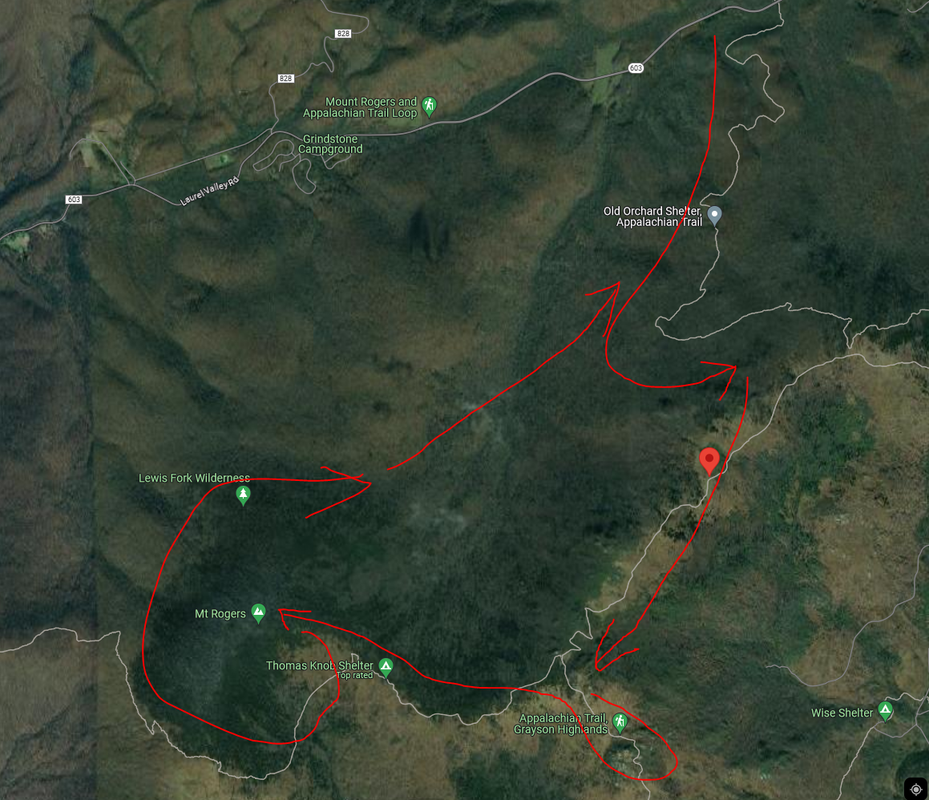
    I'm backpacking Mt. Rogers / Grayson Highlands for the first time, planning 3 days/2 nights generally following trails along these red arrows. I friend recommended I start on the Lewis Fork Trail off Rt. 603 and I'm not clear if there is trailhead parking there or if I need to park about a mile West and walk up the road to reach the trailhead?

    Some previous map recon had me considering driving to Scales campground to start. How is the road leading to Scales? I saw a comment somewhere suggesting it was heavily rutted and took a couple hours. I do have 4 wheel drive but mostly thinking about the extra commute time. The thing I liked about this was it looked like I might get to spend more time up in the higher/open terrain which is what I am really looking forward to.

    Regarding water - a previous thread here says there there is a water source at (36.668693, -81.511431) and then at Thomas Knob Shelter. If true these 2 sources fit my itinerary pretty good.

    Also a previous thread mentioned a Crest Trail Loop that I'd love to hear more about. In AllTrails they show Crest Trail as a bicycling trail and I was wondering if instead I should consider hiking along PIne Mountain Trail that parallels Crest Trail.


    GH.png

  2. #2
    Senior Member BuckeyeFan's Avatar
    Join Date
    Dec 2014
    Location
    Warrenton, VA
    Hammock
    Dutch Chameleon or DIY Robic XL
    Tarp
    Superfly
    Insulation
    DIY UQ & CDT TQ
    Suspension
    Whoopie Slings
    Posts
    482
    That exact route was my first trip to Mt Rogers. There is / was a parking area at 603, but be sure to secure all belongings since this parking area is not within the park. The hike up to the top after Old Orchard is a knee breaker. Water shouldn't be an issue. Be sure to hit the uphill to Wilburn Ridge before the heat of the day since there's absolutely no shade. If memory serves, there's a stream crossing shortly before the climb. The spring at Thomas Knob is reliable and a short distance behind the shelter. Years ago, there was a persistent black bear at Thomas, so store food appropriately. From Thomas back to 603 is a nice stroll and you may be able to grab a shower at Grindstone Campground.

    Sent from my motorola one 5G ace using Tapatalk

  3. #3
    New Member wahowad's Avatar
    Join Date
    May 2019
    Location
    Charlottesville, Virginia
    Posts
    16
    I'm actually taking the Lewis Fork Trail, but it looks to run approximately parallel to the Old Orchard trail so probably also similarly a tough ascent? I like to hike but slightly discouraged to hear it is a knee breaker. I can power through it - take breaks as needed - but I was wondering if the Appalachian Trail approach to the Crest Trail would be any better?

    I assume up along Crest Trail / Pine Mtn / Wilburn is pretty popular so should I expect to be able to scrounge up any firewood? If it's all picked over I can save a half pound and leave my pruning saw home.

  4. #4
    Senior Member
    Join Date
    Jul 2017
    Location
    Cary, NC
    Hammock
    Yes
    Tarp
    Doors for sure
    Insulation
    Love some down
    Suspension
    Usualy helps
    Posts
    412
    Below is a link to the loop that I do that looks like what you are trying to do. I usually go counter clockwise and stay near thomas knob. If I am stretching it out to 2 nights, I'll stay the second night at old orchard and have an easy hike out the last morning. There is water at both. I think that the through hiker bubble is through there by now, but probably some still coming up the trail. I wouldn't plan on staying at the shelters.

    https://www.alltrails.com/explore/ma...?u=i&sh=6vllgy

  5. #5
    New Member
    Join Date
    Jul 2018
    Location
    High Point, NC
    Hammock
    DIY grizz bridge
    Tarp
    Dyneema by HG
    Insulation
    DIY climashield
    Suspension
    Straps
    Posts
    2
    I've been in that area before. On the attached picture is a red circle where there is a wide spot on the shoulder of the road that 2-3 cars can park at. As BuckeyeFan said, lock everything up because the only creature that might watch your car are the cows in the pastures on either side of the road. Across from that parking area is opening in the pasture fence for hikers and a nice little walk thru that pasture to the trail head. I can't speak for all of the Lewis Fork Trail because we took the Cliffside spur and camped the first night around where that red asterisk is shown on the attached photo. The hike up the Cliffside Trail was tough, but if 3 fiftyish year old out of shape dads can do it I'm sure you'll be fine.IMG_9248.jpg

  6. #6
    New Member UncleBubba's Avatar
    Join Date
    Aug 2017
    Location
    Sneads Ferry, NC
    Hammock
    Chknbone Special
    Tarp
    WarBonnet Minifly
    Insulation
    Hammock Gear
    Suspension
    Dyneema Straps
    Posts
    31
    Other parking options include Grindstone Campground and Elk Garden trailhead. Grindstone Campground is just down the road from where you are thinking of parking. Cost is $5.00 per day. Be sure to pay. They will tow your car if you don't have the hang tag in your window. Elk Garden trailhead is on Rt. 600. Free parking. I have used both without any issues.

  7. #7
    Senior Member
    Join Date
    Jul 2017
    Location
    Cary, NC
    Hammock
    Yes
    Tarp
    Doors for sure
    Insulation
    Love some down
    Suspension
    Usualy helps
    Posts
    412
    The Fox Creek Trailhead (AT & 603) parking has room for about 10 cars. I have seen people there doing trail magic for when the AT hiker bubble was coming through, but they should be mostly gone by now. Never was concerned about leaving a vehicle there since there is a lot of hiking and vehicle traffic by there and I have parked there since they started charging for parking at Grayson Highlands a few years ago.

    Here is a link to a video from the loop:

    https://youtu.be/fkFJX2cyrr4?si=ksmKtQcH5AVYix2f

  8. #8
    New Member UncleBubba's Avatar
    Join Date
    Aug 2017
    Location
    Sneads Ferry, NC
    Hammock
    Chknbone Special
    Tarp
    WarBonnet Minifly
    Insulation
    Hammock Gear
    Suspension
    Dyneema Straps
    Posts
    31
    The Gaia GPS App (iPhone) has a good map of GHSP. Shows the water sources.

  9. #9
    New Member wahowad's Avatar
    Join Date
    May 2019
    Location
    Charlottesville, Virginia
    Posts
    16
    Thanks folks! My trip was AWESOME! Really loved the openness of the Highlands with the open meadows and spruces. Pine Mountain and Wilburn Ridge were amazing.

    I found an additional water source near the bear box below Pine Mountain (aside from plenty of tiny creeks that would have sufficed in an emergency). It is at 36.65414, -81.52363. I saw a lot ponies with newborns and longhorn cattle. I was only on the AT for a couple miles but saw a good number of thru hikers especially near Thomas shelter where every campsite was taken (I arrived there early so had grabbed one).

    I ascended by parking on 603 and using the Lewis Fork Trail and Cliffside trails. It was hard but I took breaks and made it up. I was worried about my truck being on the side of the road, but when I returned it was untouched. In fact I had somehow left it unlocked and nothing was taken .

    Definitely going back, but I will plan a route that keeps me more in the open Highlands. I think I want to loop around to include Scales (or even drive to it and start/stop there) and include Stone Mountain. Or I can do the backpackers parking lot, but I'm interested in driving my truck to Scales if that is doable. Looks like the approach to Scales is from the North on Pine Mountain Rd.


    Last edited by wahowad; 05-25-2024 at 09:24.

  10. #10
    Senior Member BuckeyeFan's Avatar
    Join Date
    Dec 2014
    Location
    Warrenton, VA
    Hammock
    Dutch Chameleon or DIY Robic XL
    Tarp
    Superfly
    Insulation
    DIY UQ & CDT TQ
    Suspension
    Whoopie Slings
    Posts
    482
    Glad to hear your trip was a success. Now that Grayson is in your blood, you'll be back.

    Sent from my motorola one 5G ace using Tapatalk

  • + New Posts
  • Similar Threads

    1. Grayson Highlands - Crest Trail water source
      By wa4chq in forum Southeast
      Replies: 15
      Last Post: 04-21-2018, 07:50
    2. Grayson Highlands Loop Trip
      By CJK in forum Southeast
      Replies: 4
      Last Post: 09-10-2014, 15:59
    3. (Video) Grayson Highlands loop
      By TallPaul in forum Trip Reports
      Replies: 23
      Last Post: 06-17-2013, 12:23
    4. Vid:Va/Classic Grayson Highlands Loop
      By MedicineMan in forum Trip Reports
      Replies: 32
      Last Post: 06-07-2013, 08:24
    5. Grayson Highlands Loop
      By Mike_O in forum Hangouts, Campouts, and Trip Planning
      Replies: 7
      Last Post: 07-22-2011, 08:08

    Bookmarks

    Posting Permissions

    • You may not post new threads
    • You may not post replies
    • You may not post attachments
    • You may not edit your posts
    •