


There were once three adventurers, a grad student, a musician, and an airline pilot who went on a 3-day tour of Linville Gorge. The plan was to do a shuttle hike from the east rim to the west rim and have a nice relaxing weekend in the Gorge. We did the former and, barring all the complications (and that's a big caveat), did the latter as well. Little did we know of the trials that awaited us in the Big Ditch.
Our planned itinerary was Hawksbill to Ledge to Spence Ridge to Linville Gorge to Conley Cove to the car. Here's what actually happened.
linville_map_trip.jpg
We staged a vehicle at the top of Conley Cove and drove around to Hawksbill and set off at around 9:30 PM on Friday. I mistakenly remembered the campsite at the intersection of Sitting Bear and Jonas Ridge and thought we could camp there since Hawksbill was occupied. Well, we got to the intersection of Hawksbill and Jonas Ridge and set up camp in the saddle. The weather had been warm and breezy, and just as we finished dinner, we got a little rain, which drove us to our hammocks and sleep.
After a leisurely breakfast the next morning, we packed up and headed out on the Hawksbill Climbing trail around 10:30, thinking it joined up with Ledge trail. When the climbing trail petered out, we just headed off in a downward-ish direction, thinking we would pick up the Spence Ridge in a little while. We did not.
At first the going wasn't too bad, the forest was rather open, and other than navigating around a few ledges, was quite nice. But then the Rhodies started coming in, and the going got a LOT slower.
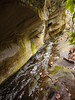
P1110827.jpg
We stopped for lunch by a little spring, in the shade of some towering Rhododendron bushes and contemplated the possibility that maybe we weren't quite where we thought we were, but consoled ourselves that in the worst case scenario, we get all the way to the river, we just head downstream until we hit the bridge. Easy peasy. This is much easier said than done, as the Gorge was soon to show us. This false sense of reassurance served to keep our spirits high as we descended into the Rhodies, which would open up as if to tease us, only to close back in mere feet later.
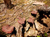
As we followed the water down, we saw lots of interesting sights, and I thought about how, since we weren't on the trail, the scenes we were looking at were probably very seldom seen by people.

We eventually reached the river, and we took a break while we discussed our next move. Do we go south or north to find the bridge? After consulting the topo, our pilot decided to take a short scouting walk to see if he could see the bridge to the south (the thin red line going south towards the bridge on the map). Just as we were about to go looking for him 45 minutes later, he returned rather confident that the bridge was further south, just around the bend. I decided to take a similar excursion to the north for the same reasons. I decided to go out 20 minutes and return within 45 total. Even without my pack, it was slow going through all the dense Rhodies and Greenbriar, and I think I only got about .2 miles before my 20 minutes were up. Judging by the terrain, and looking up at Wiseman's View (I thought I was looking at Conley), I was 95% confident we needed to go north to hit the bridge. As I began my trek back, I dreaded more and more the thought of going through one more thicket of Rhodie, so I took my shoes and pants off and tied them around my chest and waded down the (ICE COLD!!)river. This was much quicker and easier than climbing through ravines filled with dead hemlock trees and vines and Rhodies. I Marco Polo'd my way back to my companions, who told me that while I was gone, our pilot realized he had downloaded a GPS track of our intended trails, and that we definitely needed to go south. I had been confident we needed to go north, but I'm glad I didn't belabor the point, since I was wrong.
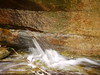
We worked our way south and broke out onto the rocks lining the river and made our way downstream.
P1110858.JPG
It wasn't too long before our hopes of reaching the bridge and camping across the river were dashed on the very rocks we stood on. A rock face was in front of us, a cliff to our left, and the river to our right. As we weighed our (dwindling, like the light was beginning to) options, we decided to climb the rock face and see what was beyond. It looked reasonable beyond, so we hauled up the packs with some extra amsteel I kept in my pack, and then I made a harness for our little border collie, and up she went.
P1110860.jpg
As we crawled around to the back side of the boulder, our musician slipped on a wet bit of rock and went careening towards the water, only to (miraculously) land on her feet just short of taking a dive into the water. Once we had all gotten to solid ground and caught our collective breaths, we decided to push on and try to make the bridge. A few hundred yards later, we could see the bridge!
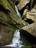
But our high hopes were AGAIN dashed by yet another rock face and this time impassable cliff. We made the executive decision to retrace our steps to the small beach below our first river cliff and make camp. The camp itself was very nice. Plentiful driftwood to burn, enough trees for a few hammocks, a gorgeous waterfall to photograph, and a river to lull us to sleep.

As we got set up, I saw an opportunity for ingenuity. I remembered a thread on hanging hammocks from rocks, and managed to set up our musician's hammock in the rock.
P1110908.JPG
After a few failures, I got it to hold, and once I'd bounced on it for a bit, I was confident it would hold (and it did).
Dinner was a quiet affair, with each of us mostly thinking about our own aches and pains, and trying not to think about tomorrow. We ate well, and after dinner, as I was laying on the beach (that phrase sounds out of place here) watching the clouds pass, I saw a BRIGHT meteor streak across the sky BELOW THE CLOUDS! It was seriously headlight-at-500-yards bright. I've never seen anything like it.
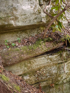
After that, I figured the night couldn't get any better and decided to hit the sack and try to get some sleep. I slept like the dead, and we woke up early to try and get an early start tackling the impassable cliff. After a hearty breakfast and plenty of water, our pilot decided to again scout ahead. After about 30 minutes and getting a little worried, we hear a distant whoop. He had made it to the bridge! After exchanging Whoo buddy's, he disappeared for another 30 minutes. We then proceeded to follow him up and around the impasse, crawling along under the cliff face to avoid the Rhodies as much as we could. The terrain and vegetation reminded me of a jungle in places, it was so sheltered and moist. The rock faces were phenomenal. So many different textures and angles, I imagine there are lots of fossils hidden in there.

Which layer is not like the others? by acercanto, on Flickr
After about an hour, we had finally made it the 600-ish yards to the bridge and stopped for a well-deserved snack and photos.
P1110965.JPG P1110962.JPG
A group of hikers from Asheville came through, and allayed some of my dread of the climb up Conley Cove by letting us know that it wasn't too bad. Compared to the previous day, it was a cake walk! Walking on trail again was such a huge difference. I did notice that ironically, I was watching my feet much more than I had the day before and had to remind myself to look up and enjoy the scenery, where yesterday my head had been on a swivel the whole time, and I saw so much more of my surroundings. That will merit more thought and experimentation.
We made it to the top of the Gorge in much less time than we had anticipated, and were off the trail by 2:30. Once we picked up my truck, we slogged over to Louise's for some food and a sink. I had the trout, and of course strawberry rhubarb pie!
It was quite the adventure, and now that it is behind me, I can look back on it and say that I enjoyed it very much. Even in the hardest parts, it was beautiful, and we got to see parts of the Gorge not many people have seen.
Thanks for reading, and I hope to see more of the Gorge soon.
More pictures are on Flickr.
PuckerFactor


 Reply With Quote
Bookmarks